← Home · Geophysics

Electrical Resistivity Testing & VES Surveys in Whangarei

Together, we solve the challenges of tomorrow.

LEARN MORE →

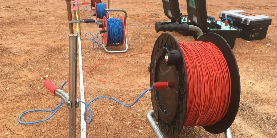
The ground beneath Kamo tells a different story than the reclaimed land near the Town Basin marina. In Kamo, you often find stiff residual clays overlying basalt at shallow depth; down by the Hatea River, soft alluvial silts and organic layers can extend 10 metres or more before hitting competent rock. This contrast is exactly why electrical resistivity testing matters in Whangarei. A vertical electrical sounding (VES) survey measures how the subsurface resists current flow, translating that into a layered model of soil, weathered rock, and groundwater. The team runs Schlumberger arrays across sites from Tikipunga to Onerahi, building resistivity profiles that help engineers decide where to sample, how deep to found, and whether saline intrusion or perched water tables will complicate the excavation. When the resistivity profile flags a low-resistivity zone at 6 metres, it often lines up with the soft marine sediments that define Whangarei's harbour-edge geology—and that's exactly the kind of intelligence you need before committing to a foundation design. We often pair the resistivity data with CPT testing to ground-truth the geoelectric layers against measured tip resistance and pore pressure, giving you a calibrated site model that reduces uncertainty in tender documents.

A good resistivity profile across Whangarei's volcanic terrain reveals not just layer thicknesses but the groundwater pathways that control slope stability and excavation dewatering.

Methodology and scope

The field setup starts with a resistivity meter, four stainless steel electrodes, and a cable reel that runs 200 metres when the site allows. For a standard VES in Whangarei, the crew lays out a Schlumberger array with current electrode spacing expanding from 1.5 metres out to 100 metres or more, depending on target depth. As the spacing increases, the injected current penetrates deeper, and the measured apparent resistivity reveals layer boundaries: the transition from dry volcanic ash to saturated basalt shows up as a sharp drop, while the contact between weathered greywacke and fresh rock produces a gradual increase. Whangarei's subtropical climate means the top metre can be bone-dry in February and fully saturated in July—seasonal resistivity swings of 30% are common in the near-surface. The team accounts for this by running reciprocal measurements and checking contact resistance at every station. For deeper investigations—like mapping basalt flow contacts beneath the Whangarei Central commercial zone—we combine VES with MASW surveys to cross-check shear-wave velocity against resistivity, a dual-parameter approach that discriminates between clay-rich weathered zones and competent bedrock far more reliably than either method alone.
Electrical Resistivity Testing & VES Surveys in Whangarei
Technical reference image — Whangarei

Local geotechnical context

NZS 4404:2010 and NZGS guidelines frame the due diligence expected on subdivision and building consent applications in Whangarei District, and resistivity surveys are often the fastest way to tick the subsurface investigation box for larger greenfield sites. The risk of skipping this step is concentrated in two Whangarei-specific problems: buried soft organic layers in the Hatea floodplain and undetected perched groundwater on volcanic slopes. An organic silt lens just 800 mm thick, invisible from the surface, can cause differential settlement if a lightly-loaded slab bridges across it; a resistivity survey picks up that lens as a low-resistivity anomaly because of its high water content and ionic concentration. On the basalt slopes above Whangarei Heads Road, perched water tables form where clay-filled paleochannels trap rainfall—failing to identify these before cutting a building platform leads to chronic drainage problems and softened bearing strata. A well-executed VES survey maps both the depth to permanent groundwater and any perched zones, giving the geotechnical engineer the data needed to design subsoil drains or adjust foundation levels before the first excavator arrives.

Need a geotechnical assessment?

Reply within 24h.

Email: [email protected]

Typical values

ParameterTypical value
MethodSchlumberger VES, dipole-dipole profiling
Max investigation depth80–100 m (Schlumberger array)
Electrode array4-electrode, stainless steel stakes
Measurement range0.1–100,000 ohm-m
Data processing1D inversion (VES), 2D resistivity imaging
Reporting standardNZGS guidelines, NZS 4404:2010 context
Typical survey duration2–4 hours per VES sounding

Other technical services

01

Vertical Electrical Sounding (VES)

A single-point Schlumberger sounding that produces a 1D resistivity profile directly beneath the array centre. Ideal for foundation depth assessment, groundwater table mapping, and bedrock profiling on residential and commercial lots across Whangarei.

02

2D Resistivity Imaging

Multi-electrode profiling along a survey line, generating a cross-section of subsurface resistivity. Used for pipeline routes, road cuttings, and landslide investigation where lateral continuity of layers must be traced over tens or hundreds of metres.

03

Combined Geophysics Package

VES or 2D resistivity paired with MASW or seismic refraction. The resistivity identifies water and clay content while the seismic method measures stiffness—together they provide a comprehensive ground model for complex sites like the Whangarei Hospital redevelopment or hillside subdivisions.

Regulatory framework

NZS 4404:2010 – Land development and subdivision infrastructure, NZGS guidelines – Geotechnical investigation and reporting, AS 1726:2017 – Geotechnical site investigations (referenced in NZ practice)

Questions and answers

What does a typical electrical resistivity survey cost in Whangarei?

For a standard VES sounding with full interpretation and report, budget between NZ$1.010 and NZ$1.560 depending on access, array length, and whether 2D profiling is added. Sites requiring multiple soundings or difficult terrain may fall toward the upper end. We provide a fixed-price quote after a brief desktop review of your site.

How deep can you investigate with VES on Whangarei's basalt terrain?

With a Schlumberger array using maximum current electrode spacing of 100 to 120 m, we typically reach investigation depths of 80 to 100 m—more than enough to penetrate the basalt flows and weathered greywacke basement underlying most of Whangarei. The limiting factor is site geometry: small urban lots restrict electrode spread, which caps depth around 30 to 40 m.

Will the survey work on water-saturated ground after heavy Whangarei rain?

The reference range for this service in Whangarei is NZ$1.010 - NZ$1.560. The final price depends on the project scope and volume.

Location and service area

We serve projects in Whangarei and surrounding areas.

View larger map